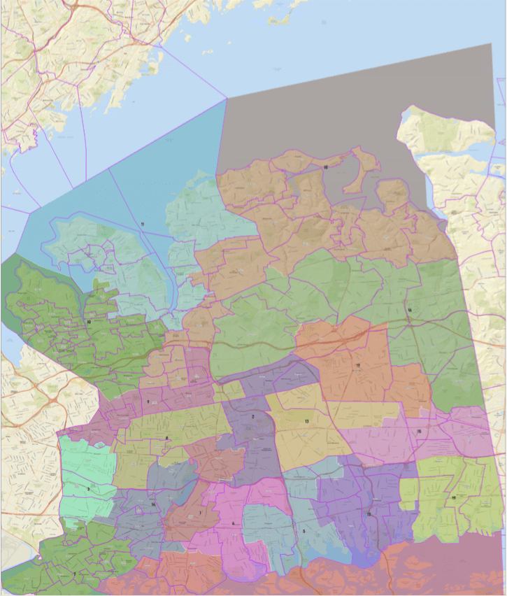
The Republican-controlled Nassau County Legislature voted Monday along party lines to adopt a map with newly drawn electoral districts which Democrats claim is illegal and favors their GOP counterparts.
The Legislature voted 11-7 to adopt maps that were presented by the majority caucus Feb. 21. Minority Leader Kevan Abrahams (D-Freeport) criticized the Republican legislators for working in “secrecy” so they can keep their advantage over the next decade.
Republican Presiding Officer Rich Nicolello said the new maps featured Democratic officials having an enrollment edge in 15 of the 19 legislative districts, but Abrahams disagreed.
“It is not surprising that such a deeply flawed, self-serving process would produce an extreme partisan gerrymander that disenfranchises Nassau’s minority communities and violates numerous federal, state, and local laws,” Abrahams said in a statement. “By passing this illegal map, the Republican Majority has recklessly placed Nassau County on a collision course towards numerous lawsuits that will ultimately cost taxpayers millions of dollars.”
“Is this map perfect?” Nicolello asked during Monday’s session. “No. But perfection is impossible in redistricting. This map is a fair map, it provides equal representation for all our residents and protects community interests as much as possible.”
Abrahams, under the new map, is put into a district inhabited by more Republicans than the current 1st District. Democratic county Legislator Arnold Drucker, in a statement, expressed his displeasure with the proposal that splits Plainview and redraws the lines in his district.
“The current proposal is an extreme partisan gerrymander that carves apart Plainview and other communities across the 16th Legislative District,” Drucker said. “This is not about the political fate of one person over another – it is much more significant. This is a brazen attempt to dilute and render irrelevant the voices of all Democrats residing in the 16th District and it must not stand.”
Legislator Josh Lafazan will be pushed into the 16th Legislative District, represented by Drucker, according to the map.
Abrahams said there is likely no scenario in which the maps “will not be challenged in court.” Other changes to North Shore areas include the expansion of the 10th District into Munsey Park, Plandome and Plandome Manor.
Under the map, the villages of Roslyn, Roslyn Harbor and parts of Glenwood Landing are included in the 11th District, with Greenvale, East Hills and other parts of Glenwood Landing in the 18th District, Roslyn Estates in the 10th District and parts of Roslyn Heights in the 9th District.
The 9th District population will increase by 1,160 residents, the 10th District will increase by 780, and the 18th District will increase by 709, but the 11th District population will decrease by 246, according to data released by the Legislature. The 9th District’s population increase is the second-largest under the newly drawn map, with 18 fewer residents than the 2nd District.
The GOP’s Nicolello is the 9th District legislator, the 10th District is represented by Republican Legislator Mazi Melesa Pilip, the 11th District is represented by Democrat Delia DeRiggi-Whitton and the 18th District is represented by Josh Lafazan, who ran in this past year’s Democratic primary for the state’s 3rd Congressional District.
Abrahams bashed the GOP proposal for “diluting the voting power of minority communities across” Nassau County, including having an “Asian-American influence district.” In 2010, Asian Americans made up 7.6 percent of Nassau’s population, which increased to 11.7 percent in 2020, according to data from the U.S. Census.
Abrahams said the map goes against parts of the federal Voting Rights Act and the John. R. Lewis Voting Rights Act of New York.
The map was last redrawn in 2013. Democratic officials have chastised Republicans for their lack of transparency in developing the 2023 map. They contend that the Republican map allows officials to select their representatives rather than the public.
Republicans held a 12-7 majority in the Legislature before Republican Steve Rhoads stepped down to become a state senator. A special election Tuesday to fill Rhoads’s seat will decide if the majority will return to 12-7 or not.
The Legislature was put in charge of reviewing maps, presented by the county’s Temporary Districting Advisory Commission, which split along party lines and failed to agree on a map of its own.
Commission Chairman Frank X. Moroney said in December that Democratic Committee member David Mejias’ prediction of litigation was something he had heard from the start of the redistricting process.
Moroney said Republican officials asked the Democratic commission to work across the aisle, saying the Democrats “did not want to do that.”
“The only thing that happened here is that the Republicans of Nassau County have guaranteed litigation over an illegal map,” Mejias said in December. “If and when they lose, it’s going to cost the taxpayers millions of dollars.”
The Legislature was required to select newly drawn lines before March, officials said.


